Nikon 550 Forestry Laser RangeFinder
Laser beams offer a remarkable array of innovations, and they are employed in many different areas. These include the use of laser scalpels in medicine, laser beam machines in industry, and laser technology in audiovisual equipment such as CDs and DVDs. Some of us may even have seen laser beams used at concerts and other events as tools to dramatize performances. Laser beams literally travel at lightning speed?300,000 kilometers per second; the equivalent of seven and half times around the world in one second! Moreover, a laser beam is able to travel long distances and still hit its target as a small dot without dispersing. Laser rangefinders were developed by utilizing this special laser beam feature.
More and more golfers are using laser rangefinders to measure target distances on golf courses. Laser rangefinders help golfers develop their sense of distance by showing actual distances. Many golfers prize laser rangefinders as instruments that can help boost their game. Knowing exact distances under changing situations due to wind and a golf course’s topography is not only a huge advantage for a golfer, but can help develop his or her golfing skills. Laser rangefinders can also measure both height differences and slope angles on golf courses, enabling golfers to more easily picture how best to play their shots.
A laser rangefinder measures a distance by projecting laser beams to a target and measuring the traveling time taken by the beams to be reflected off the target and returned to the instrument.
When taking a measurement, a laser rangefinder emits hundreds of laser beams in an approximate half-second period to boost measurement accuracy. This also improves accuracy, as a single laser beam can miss a target that is too small. Furthermore, when measuring the distance to a golf flagstick, a rangefinder may also receive incoming signals reflected off trees in the background, in addition to signals reflected off the flag itself. The rangefinder’s Target Priority Switch System* overcomes this problem. If the user selects First Target Priority mode, the rangefinder displays the distance of the nearest point, in this case the flagstick, instead of the distance to the trees in the background. Nikon’s laser rangefinders provide accurate measurements instantly and easily according to users’ needs. This is why they have won praise from so many golfers.
Applications
| |
Forestry surveys
|
 Exploring ruins Exploring ruins |
Hunting
|
|
Golfing or caddying
|
Sailing
|
Features:
- In addition to actual distance measurement, height, vertical separation (difference in height between two targets), horizontal distance and angle can be easily measured.
- The results are displayed on both internal and external LCD panels. The external panel displays all results simultaneously.
- Two measurement modes (Target Priority Switch System) are available:
First Target Priority Mode displays the range to the nearest target taken from multiple results obtained with a single measurement.
Distant Target Priority Mode displays the range to the farthest target taken from multiple results obtained with a single measurement especially useful for forestry and hunting.
- High-quality 6x monocular with multilayer coating produces bright images.
- Waterproof (up to 1 meter for 10 minutes) but not for underwater usage. The battery chamber is water resistant.
- High-eyepoint design allows easy viewing even with eyeglasses.
- Capable of measuring different distances in succession, for up to 20 seconds, when the button is held down.
- Measurement range: 10-500 m/11-550 yd./33-999 ft.
- Display in feet as well as metres and yards is available with this model.
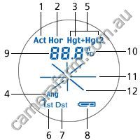
Internal display
| 1. |
Actual (linear) Distance |
| 2. |
Horizontal Distance |
| 3. |
Height |
| 4. |
Angle |
| 5. |
Height between two points |
| 6. |
First Target Priority mode |
| 7. |
Distant Target Priority mode |
| 8. |
Battery condition |
| 9. |
Distance |
| 10. |
Unit of measure (m/yd.)
(no unit displayed for ft.) |
| 11. |
Target mark ( ) ) |
| 12. |
Laser irradiation ( ) ) |
|
 |
|
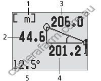
External display
| 1. |
Measurement unit (m/yd.ft.) |
| 2. |
Height |
| 3. |
Actual (linear) Distance |
| 4. |
Horizontal Distance |
| 5. |
Angle () |
|
 |
|
Measurement example (2-point height measurement)
When the measurement is successful, you see the height from the base to the top displayed on the internal LCD with Hgt + Hgt2 (solid).
For more information, refer to the external LCD.
“Base” and “top” can be switched.
Specifications
| |
|
Forestry 550 |
|
| Measurement range |
|
Distance:10-500m/11-550 yd./33-999 ft.(*999 ft.: 304.5m/333 yd.)
Angle: 89 |
|
| Distance display (Increment) |
|
[Internal Display]
Act (Actual Distance):
every 0.5m/yd., 1.0 ft. (shorter than 100m/yd./ft.)
every 1.0m/yd., 1.0 ft. (greater than 100m/yd./ft.)
Hor (Horizontal Distance) and Hgt (Height):
every 0.2m/yd., 0.5 ft. (shorter than 100m/yd./ft.)
every 1.0m/yd., 1.0 ft. (greater than 100m/yd./ft.)
Ang (Angle):
every 0.1 (less than 10)
every 1.0 (more than 10)
*Downward angle from the horizontal line: with display "-"
[External Display]
Act (Actual Distance): every 0.5m/yd., 1.0 ft.
Hor (Horizontal Distance) and Hgt (Height):every 0.2m/yd., 0.5 ft.
Ang (Angle): every 0.1 |
|
| Finder |
|
Magnification (x) |
|
6 |
|
| Effective objective diameter (mm) |
|
21 |
|
| Actual field of view () |
|
6.0 |
|
| Exit pupil (mm) |
|
3.5 |
|
| Eye relief (mm) |
|
18.2 |
|
| Dimensions (LxHxW) (mm) |
|
130x69x45 |
|
| Weight (g) (excluding battery) |
|
210 |
|
| Power source |
|
CR2 lithium battery x 1 (DC3V)
Auto power shutoff function equipped (after 30 sec.) |
|
| Safety and EMC |
|
VCCI class B, Class 1M laser product (IEC60825-1:2001),
Class 1 laser product (21CFR 1040.10 and 1040.11) CE,
EMC directive, Fcc Part15 subpart B Class B, c-tick, WEEE |
The specifications of the product may not be achieved depending on the target object's shape, surface texture and nature, and/or weather conditions.
Note: The origin of the technique of this Laser Rangefinder with inclinometer is the Surveying Instruments incorporated measuring capability of both distance and angle which were developed by Nikon Corporation. Among such products, especially, the first highly advanced electronic model, the Total Station DTM-1, is the root (Sold in 1985).


